


The Science of Indonesia's Surprise Tsunami
Dozens of earthquakes rocked the region, but a tsunami didn't seem imminent. Then the massive waves began crashing in.
On Friday, a powerful 7.5-magnitude earthquake shook the Indonesian island of Sulawesi, just after 5:02 PM Western Indonesian Time. Dramatic videos revealed the eerie growth of a mounting wave in a bay near Palu eventually crashing into the coast, sweeping away beach structures as onlookers scatter.
Scientists were surprised by the strength of the ensuing tsunami. And experts suggest that the area's unique geology could be to blame for the unexpected progression of the disaster.
The earthquake followed a series of temblors that began around 2:00 PM WIB with a 6.1-magnitude quake. The ground continued to roil with 27 aftershocks that eventually gave way to the intense, shallow 7.5-magnitude temblor centered about 6 miles deep, according to the U.S. Geological Survey. Since then, dozens of aftershocks continue to rock the island.
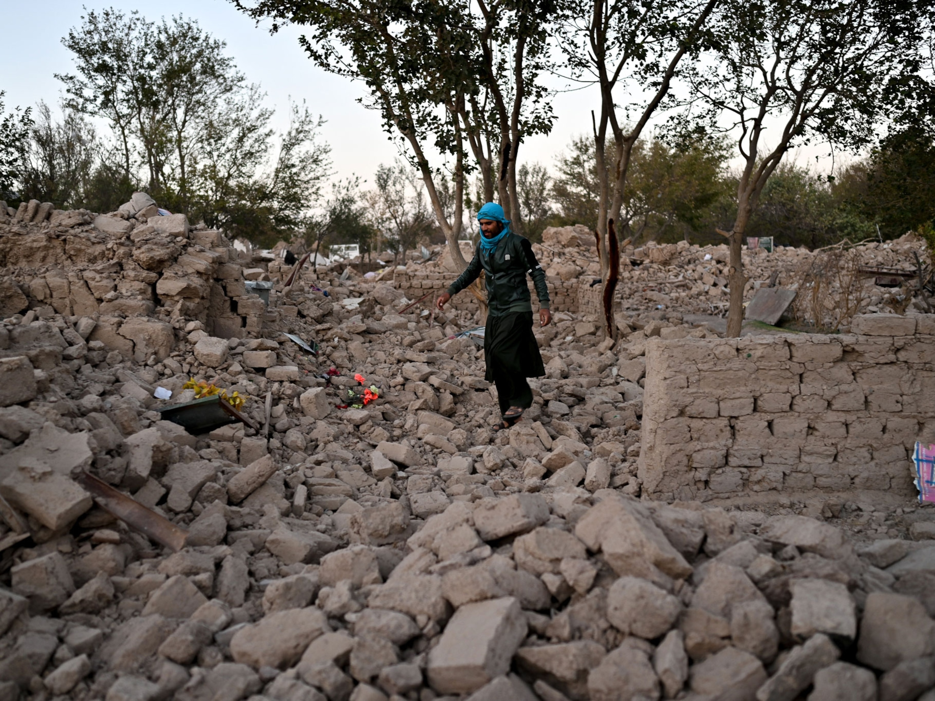
As of Sunday evening, local time, the death toll had jumped to 832 people—and officials worry that number could still sharply rise since search-and-rescue teams have yet to reach many regions. This includes the regency of Donggala, home to some 300,000, where communication remains limited and landslides have severed rescue workers' access.
The total damage from the powerful quakes is still unclear—but devastation appears to be widespread. According to a statement from the Badan Nasional Penanggulangan Bencana (BNPB), the Indonesian natural disaster agency, the earthquakes have caused power outages, which have crippled communication, but local agencies are working to resolve the situation. Sutopo Purwo Nugroho, BNPB spokesperson, announced via Twitter that the Indonesian army has been deployed to assist with search and rescue.
Making Waves
Indonesian Agency for Meteorology, Climatology and Geophysics (BMKG) initially issued a tsunami warning but soon retracted it based on analyses at the time. Yet monstrous waves began crashing on shore, captured in videos that quickly began circulating on social media. According to BNPB, the destructive waves began before the warning was lifted. But the earthquake toppled telecommunications, which prevented officials from sending proper alerts, reports The New York Times.
Because of this, the towering waves took many by surprise. One particular video seems to be recorded from the upper floors of the circular parking structure at the Palu Grand Mall, showing waves rushing in below. It cuts off as the crowd starts to run, seeking safety from the wall of water.
Tsunamis typically are the result of the abrupt motion of large submarine earthquakes at tectonic plate boundaries. And earthquakes are not uncommon in Indonesia; the island chain sits within what's known as the Ring of Fire, a curving horseshoe-shaped chain of tectonic plate boundaries that hugs the Pacific basin. It is home to around 90 percent of the world's earthquakes.
But the monster waves were unexpected for this particular quake.
The 7.5-magnitude earthquake appears to be the result of what's known as a strike-slip fault, which takes place as two blocks of crust grind against one another, largely in a horizontal direction. Tsunamis more commonly follow vertical movement in the crust, which disrupts the overlying water and can generate massive waves crashing onshore.


“It is definitely a surprise,” says Baptiste Gombert, a geophysicist at the University of Oxford. He notes that Indonesia's geology is highly complex. A spidery web of different types of faults cut through the region, so teasing out exactly what happened is a challenge. But preliminary results hint at a few possibilities.
The tsunami might be the result of some vertical movement along the fault, Gombert says. But he finds it unlikely this could entirely explain such high waves, which were reported to stand as tall as 18 feet. “Even if there was a little vertical displacement, this is a pretty big tsunami,” he says. It's likely landslides—either submarine or from the shores—also disturbed the bay waters, causing the wave.


It's also possible that the fault cut through a submarine slope, so the horizontal movement offset the underwater hillside, causing the destructive waves. "You can compare the Palu bay with a bath tub," says Andreas Schäfer, a post-doc at Karlsruhe Institute of Technology in Germany, via email. "When you move one half of it, the horizontal displacement of the sea floor also pushed the water away and when it returned it came back as a tsunami wave." New estimates suggest the land was displaced through Palu City and the bay area, supporting this interpretation, and Schäfer created preliminary models of the event to demonstrate this effect.
The bounds of the bay itself may have also been an issue, notes Janine Krippner, a volcanologist at Concord University. “That can amplify wave height as it channels water into a smaller area,” she writes via Twitter message. New estimates of the earthquake's offset suggest that in the city of Palu, there was up to 26 feet of displacement, Gombert notes. This means that some of the waves may have formed within the bay itself, he says, "therefore closer to the city and trapped in the narrow bay."
But all of the scientists emphasize that there is still a lot of uncertainty surrounding Friday's events.
Indonesian agencies are directing locals to remain aware of continued dangers. “People are encouraged to remain vigilant,” said disaster agency spokesman Sutopo Purwo Nugroho, the AP reports. “It is better not to be in a house or building because the potential for aftershocks can be dangerous. People are encouraged to gather in safe areas. Avoid the slopes of hills.”
BNPB put out a call on their official Facebook account for anyone with internet access to help catalog the damage in Palu city and Donggala district using the collaborative online project OpenStreetMap.
Related Topics
You May Also Like


Go Further
Animals
- Orangutan seen using plants to heal wound for first timeOrangutan seen using plants to heal wound for first time
- What La Palma's 'lava tubes' tell us about life on other planetsWhat La Palma's 'lava tubes' tell us about life on other planets
- This fungus turns cicadas into zombies who procreate—then dieThis fungus turns cicadas into zombies who procreate—then die
- How can we protect grizzlies from their biggest threat—trains?How can we protect grizzlies from their biggest threat—trains?
Environment
- What the Aral Sea might teach us about life after disasterWhat the Aral Sea might teach us about life after disaster
- What La Palma's 'lava tubes' tell us about life on other planetsWhat La Palma's 'lava tubes' tell us about life on other planets
- How fungi form ‘fairy rings’ and inspire superstitionsHow fungi form ‘fairy rings’ and inspire superstitions
- Your favorite foods may not taste the same in the future. Here's why.Your favorite foods may not taste the same in the future. Here's why.
- Are the Great Lakes the key to solving America’s emissions conundrum?Are the Great Lakes the key to solving America’s emissions conundrum?
- The world’s historic sites face climate change. Can Petra lead the way?The world’s historic sites face climate change. Can Petra lead the way?
History & Culture
- These were the real rules of courtship in the ‘Bridgerton’ eraThese were the real rules of courtship in the ‘Bridgerton’ era
- A short history of the Met Gala and its iconic looksA short history of the Met Gala and its iconic looks
- Meet the ruthless king who unified the Kingdom of Hawai'iMeet the ruthless king who unified the Kingdom of Hawai'i
- Hawaii's Lei Day is about so much more than flowersHawaii's Lei Day is about so much more than flowers
Science
- Why ovaries are so crucial to women’s health and longevityWhy ovaries are so crucial to women’s health and longevity
- Orangutan seen using plants to heal wound for first timeOrangutan seen using plants to heal wound for first time
Travel
- Why this unlikely UK destination should be on your radarWhy this unlikely UK destination should be on your radar
